 ARISE Home
 ARISE Data Center
Impacts
Societal impacts
The monitoring of the Earth’s atmosphere with data from vanguard technologies using infrasound, LIDAR and airglow measurements offers a wide range of civil security applications that may possibly contribute to human welfare and safety. In the ARISE project, the collection of advanced data relative to the following phenomena will be used for monitoring extreme events and for civil security applications.
Meteorites
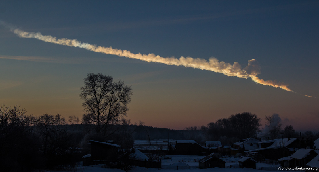
A huge meteor flew over the Urals and exploded above Chelyabinsk city, Russia, on February 15, 2013
This photo was taken at about 200km distance by a local, Alex Alishevskikh (© photos.cyberborean.org)
On 15 February 2013, a large Earth-impacting fireball disintegrated over the Ural Mountains. This extraordinary event is, together with the 1908 Tunguska fireball, among the most energetic events ever intrumentally reccorded. A preliminary estate of the explosive energy using empirical period-yield scaling relations gives a value of 460 kt of TNT equivalent.
It generated infrasound returns ,after circling the globe, at distance up to ˜95,000 km, and was detected at 20 infrasonic stations of the global International Monitoring System (IMS). For the first time since the establishment of the IMS infrasound network, multiple arrivals involving waves that travelled twice round the globe have been clearly identified. This event provides a prominent milestone for studying in detail infrasound propagation around the globe for almost 3 days as well as for calibrating the performance of the IMS network.
Moreover, combining updated broadband detection algorithms and rangedependent propagation modeling in a realistic atmosphere will improve knowledge of the physical mechanisms involved in near-Earth object interaction with the atmosphere and document possible local atmospheric perturbations.
Ultimately, continuing such studies will provide a benchmark for future studies on exploding fireballs. These observations are especially useful when events occur during the daytime and records from other observing instruments, such as Earth-based telescopes and all-sky cameras, cannot be made reliably or when an event is located over a remote area such as the vast open oceans where no surface-based recording instruments are available.
In addition, it is expected that more detailed analyses of such large events would help to advance the development of monitoring procedures to identify potentially dangerous exploding near-Earth objects.
Volcano monitoring and aviation safety
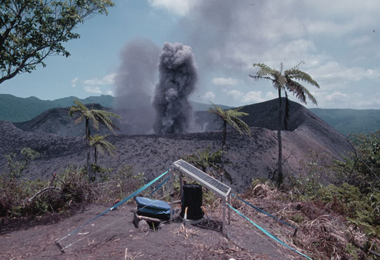
Infrasound experiment at Yasur volcano,Tanna island / Vanuatu
The global infrasound station density is steadily increasing and signals from volcanic activity are routinely recorded. The characteristics of the detected signals and the maximum range for observing these signals depend on the type of eruption. There are either effusive or explosive in their behaviour, the largest eruptions being sometimes accompanied by significant release of ash in the upper atmosphere. The geographical region covered by the ARISE project comprises volcanoes located in Europe (Italy, Iceland) and Africa (Tanzania, Democratic Republic of Congo, Comoros, La Reunion). In addition temporary portable infrasound arrays installed near the crater of active volcanoes will provide important observations and measurements. These data should help the scientific community to better understand the specificity of individual active volcanoes, and should contribute to demonstrate the active participation of Europe in volcano warning systems.
With the future completion of the IMS infrasound network complemented by national facilities, the objective of providing low-latency volcanic explosion detection notifications to Volcanic Ash Advisory Centers will become increasingly more attainable. Such early warning systems may help to prevent eruption disasters and mitigate the impact of ash clouds on aviation.
Mass movements of the Earth surface
The utilization of ARISE infrasound data to study natural hazards related to massive earth displacements (earthquakes, landslides and avalanches) is also relevant for civil security applications.
The infrasound technology detects and localizes the main surface Earth motion. Infrasound intensity maps characterizing large earthquakes may help to identify populated regions with highest disaster probability. For specific events, a detailed signal analysis and attempt will be performed to identify the location of the ground-to-air coupling sources. If available, a comparison may be made between the coupling regions and seismic intensity maps established by European seismological institutes (e.g. EMSC, national seismic networks).
Risk assessment of snow avalanche is mostly related to weather conditions and snow cover. However a rigorous validation of the forecasting modelling for avalanches is still primitive and based on visual observation. Infrasound is the only technology able to detect the pressure transients produced by avalanche. ARISE will analyse hundreds of infrasonic signals detected by infrasonic arrays deployed in the Alps to assess the feasibility to unambiguously recognize avalanches. This will have a large impact on the forecast modelling and risk management community worldwide.
During the course of the ARISE project, portable equipment may also be deployed in the Alps for measuring the characteristics of infrasound signals produced by natural and artificial snow avalanches. There are several test sites located in Switzerland and Austria where avalanche experiments are conducted every year. The ARISE project may be used to reinforce the European civil engineering teams working in the field of avalanche danger management. The detection and location of avalanches may be a good complement to local human observations, confirming the occurrence of events when visibility conditions are poor (remote mountainous area, bad weather conditions, night time). The better understanding of the avalanche infrasound signature may also help to identify and notify in advance non-observable sequences related to instability in the snow cover that would be precursor of major episodes (in a similar way as seismic foreshocks observed before major earthquakes).
Severe weather
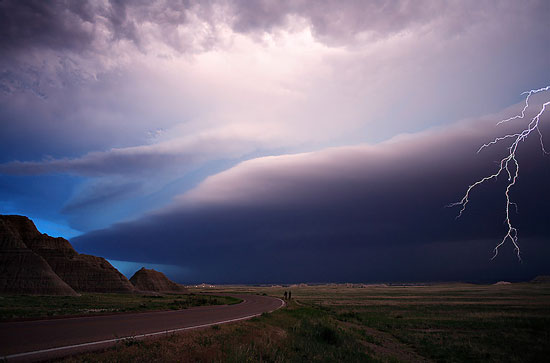
Stormchase USA may 28 2006
Courtesy Oscar Van der Velde
The collected data from the infrasound, LIDAR and airglow networks should help to improve the understanding of the upper atmosphere properties and variability in time. The information centralised in a database would provide a unique dataset for continuous and long-term monitoring of the intensity and evolution of extreme events (severe storms, tornadoes and cyclones).
Since 2005, several European countries participated in the Eurosprite campaigns using optical camera and complementary instruments to detect transient luminous events (sprites) that occur in the middle atmosphere above large thunderstorms. The ARISE ground-based observing facilities are in line with Eurosprite campaigns, introducing additional techniques for measuring the signature and investigating the generation mechanisms of infrasound from lightning and sprites.
ARISE proposes to determine the parameters that would best characterize these severe weather phenomena. In the long term applications, it would be considered to include the ARISE network observations into existing meteorological models in order to improve the accuracy in short- and medium-range weather forecasts