 ARISE Home
 ARISE Data Center
Impacts
Scientific impacts
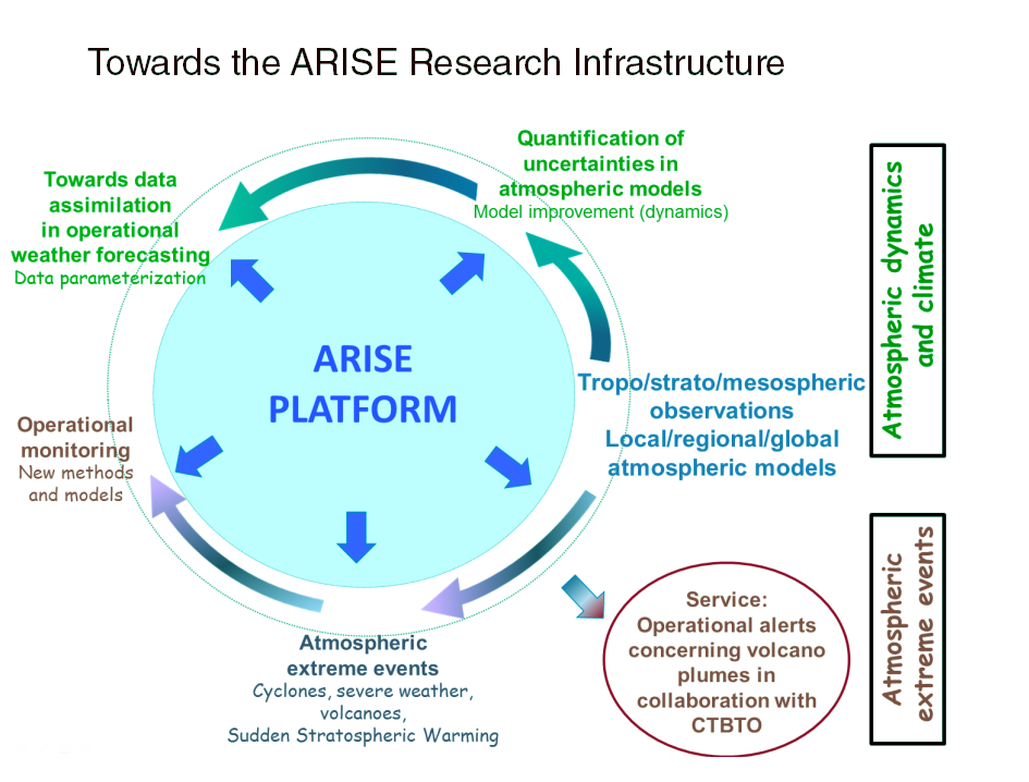
The ARISE project aims to revive existing collaborations among European scientists while developing and integrating, for the first time, a large set of complementary topics such as infrasound, gravity and planetary waves, stratosphere and mesosphere disturbances, satellite atmospheric studies and modelling of the atmosphere, and atmospheric dynamics. Data collected by these multiple networks will be analyzed to extract optimized estimation of the evolving state of different atmospheric layers, which would help to constrain the parameterization of gravity waves and to better initialize forecasts of the middle and upper atmosphere.
The expected benefits would be a better description of the atmosphere and an improved accuracy in short- and medium-range weather forecasts. ARISE measurements will also be used to improve the representation of gravity waves in stratosphere-resolving climate models, crucial to estimating the impact of a range of stratospheric climate forcing on the troposphere. In the long term, the data will be used for monitoring of middle atmosphere climate, its long-term mean trends and changes in extreme events. The benefits also include civil applications related to monitoring of natural hazards.
The ARISE Design Study project aims to integrate and coordinate scientific communities that have never previously worked together. It plans to design a large infrastructure with significant value for understanding the atmosphere. A large part of the project is dedicated to defining the specifications of new observational parameters which can be derived from the different measurement techniques at high added value. It also integrates studies and simulations about the data use for modelling of the atmosphere and weather and climate forecasting.
The ARISE impacts will be:
- to provide a new and improved set of observations of the middle and upper atmosphere for the initialization of model forecasts at unprecedented spatial and temporal resolution,
- to provide observations of gravity wave parameters for future improvement, testing and validation of numerical atmospheric models which would help to improve meteorological and climate forecasting,
- to monitor climate-related phenomena such as severe weather, thunderstorms and stratospheric warming, over a large period of time, in order to characterize their intensity and evolution over time,
- to provide a near-real time and continuous monitoring system to natural hazards such as large volcanic eruptions, surface earthquakes and avalanches, and meteorites.
The expected benefits would be a better description of the atmosphere and an improved accuracy in short- and medium-range weather forecasts. ARISE measurements will also be used to improve the representation of gravity waves in stratosphere-resolving climate models, crucial to estimating the impact of a range of stratospheric climate forcing on the troposphere. In the long term, the data will be used for monitoring of middle atmosphere climate, its long-term mean trends and changes in extreme events. The benefits also include civil applications related to monitoring of natural hazards
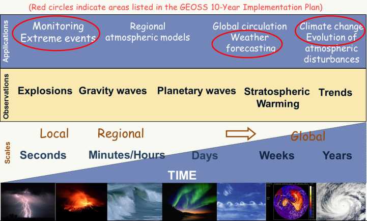
The GEOSS (Global Earth Observation System of System)international public infrastructure, encourage Earth observation systems to provide comprehensive environmental data, information and analyses for societal benefit. It supports systems such as the observation components of Europe’s Global Monitoring for Environment and Security (GMES) initiative. Three ARISE major applications related to disaster monitoring; climate and weather forecast are included in the nine societal benefit areas identified by GEOSS.